Maneuver loss is shown in meters of straight upwind distance lost (so-called VMG meters).
Maneuver loss is calculated based on previously set up timings for the maneuver. For different classes, you may need to adjust those values.
The timings are:
Tack/Gybe time before head to wind – how many seconds before head to wind will be considered as a tack/gybe (default value 5s)
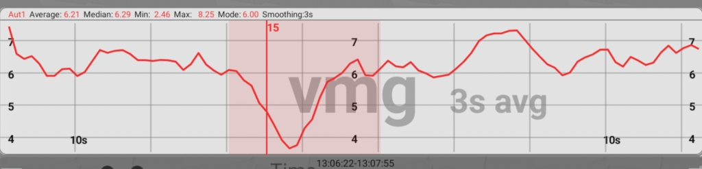
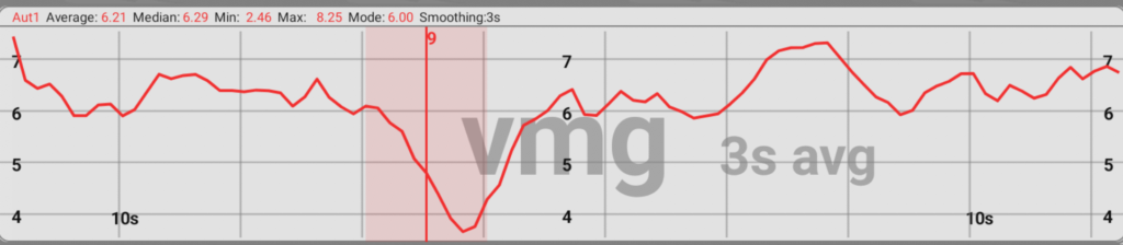
Tack/Gybe time after head to wind – how many seconds after head to wind will be considered as a tack/gybe (default value 15s)
Sailing time before/after tack – time from which the reference VMG will be taken. (default 30s)
Best VMG duration – out of sailing time before/after tack the best VMG average of this many seconds is taken as a reference value (default 10s)
In simple terms, tack loss is calculated like this: How many meters more than us upwind would another boat sail if it has sailed at the VMG of best pre/post tack reference VMG sail for the duration of our maneuver time?
To see if the timings fit your class properly, you can show on the graph screen the periods that are considered to be in maneuvers. Do this by long-pressing on graph screen, choosing Options and switching on “Color Maneuver Background”.
For slow keelboats or boats that need to get up foiling after maneuver, the “Tack/Gybe time after” number should be extended. For classes that tack fast, it could be smaller.
Choose the VMG as the value you want to see on the graph. If the colored area covers your VMG dip, then you have proper timings. Otherwise play with numbers to have it cover the whole VMG dip.
Always pay attention that maneuver loss depends on your pre/post sailing. So if your performance at that time had some issues or there was a wind change, the numbers might be off.
The faster the boats are, the loss is more reliable since GPS can not get the small distances that easily.